Task 1 · Dynamic Mixed Chart
You should spend about 20 minutes on this task. Write at least 150 words.
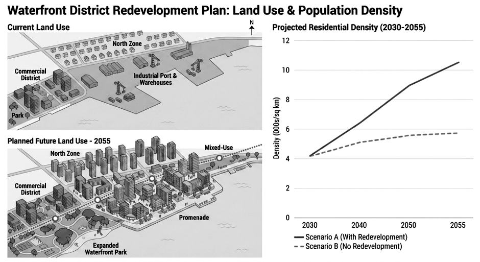
The maps and chart below illustrate the current and planned land use of a coastal city’s central waterfront district and show the projected residential population density under two different scenarios from 2030 to 2055.
Summarise the information by selecting and reporting the main features, and make comparisons where relevant.
Want to see your estimated band score?
Check your writing scorePart 1 · Band 9 Sample Answer
The maps compare the present layout of a central waterfront district with its proposed configuration in 2055, while the chart forecasts residential density with and without redevelopment.
Overall, the plan replaces a low-rise residential and industrial waterfront with a much denser mixed-use neighbourhood offering more public space. The commercial district is retained, whereas the park is enlarged and the working port disappears. Density is projected to rise far more sharply under redevelopment.
At present, detached houses occupy the North Zone, while an industrial port and warehouses cover the central and eastern shoreline. The Commercial District lies to the west beside a small park. By 2055, numerous high-rise blocks will occupy the North Zone. The port facilities and warehouses will be replaced by closely spaced mixed-use buildings extending eastwards. Meanwhile, the park will expand along the western waterfront, and a promenade will follow the southern and eastern shore. The commercial area remains in broadly the same location.
Both projections begin at just over 4,000 residents per square kilometre in 2030. With redevelopment, density climbs to approximately 6,500 in 2040 and 9,000 in 2050, before reaching about 10,500 by 2055. Without it, the figure rises to around 5,000 and 5,600 respectively, then levels off at roughly 5,700. The final gap is therefore nearly 5,000 residents per square kilometre.
Part 1 · Band 8 Sample Answer
The diagrams show the current land use of a coastal city’s central waterfront and the redevelopment planned for 2055. The graph compares projected residential density under redevelopment and no-redevelopment scenarios.
Overall, the waterfront will change from a low-density area containing housing and industry into a densely built mixed-use district. Commercial land remains in the west, while recreational space expands substantially. Redevelopment is also expected to produce a much greater rise in population density.
Currently, the North Zone consists mainly of small houses. To its south-east, warehouses and port equipment occupy much of the shoreline, while the Commercial District and a small park lie in the west. By 2055, high-rise blocks will replace the houses in the North Zone. The port and warehouses will also be removed, making way for a large mixed-use area. In addition, the park will extend across more of the western waterfront, and a promenade will run along the southern and eastern coast. The Commercial District stays in approximately its present position.
Density starts at around 4,200 people per square kilometre in both scenarios in 2030. With redevelopment, it rises to about 6,500 in 2040 and 9,000 in 2050, reaching approximately 10,500 by 2055. Without redevelopment, it grows to roughly 5,000 and 5,600 respectively, then finishes at about 5,700. The redeveloped district is therefore predicted to be almost twice as densely populated in 2055.
Part 1 · Band 7 Sample Answer
The maps illustrate the current land use of a central waterfront district and the changes planned by 2055. The graph presents two projections for residential population density.
Overall, the area will become more densely developed, with new residential and mixed-use buildings replacing houses and industrial facilities. The park will expand and a promenade will be added. Population density grows much faster if redevelopment occurs.
At present, the North Zone contains small houses. The centre and east of the waterfront are occupied by an industrial port, warehouses and cranes. In the west, there is a Commercial District beside a small park. Under the plan, high-rise blocks will replace the houses in the North Zone. The port and warehouses will become a mixed-use neighbourhood containing many new buildings. The Commercial District remains in the west, but the park will be considerably larger. A promenade will also be constructed along the southern and eastern coast.
In 2030, both scenarios show just over 4,000 residents per square kilometre. With redevelopment, this figure rises to approximately 6,500 in 2040 and 9,000 in 2050, then reaches around 10,500 in 2055. Without redevelopment, density grows more slowly to about 5,000 and 5,600 respectively, before ending at roughly 5,700. The difference is therefore almost 5,000 people per square kilometre by 2055.