Task 1 · Map
You should spend about 20 minutes on this task. Write at least 150 words.
The diagrams below show changes to a community centre building and its surrounding area between 1985 and the present day.
Summarise the information by selecting and reporting the main features, and make comparisons where relevant.
Want to see your estimated band score?
Check your writing scorePart 1 · Band 9 Sample Answer
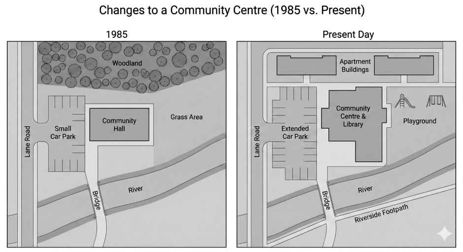
The diagrams compare the layout of a community centre and the adjoining land in 1985 with their present-day arrangement.
Overall, the site has been developed far more intensively. The former woodland and grassland have disappeared, making way for housing, an enlarged community facility and a playground. By contrast, the river, bridge and Lane Road have essentially retained their original positions, while parking and pedestrian access have been improved.
In 1985, woodland occupied most of the northern part of the site. Immediately to its south stood a relatively compact community hall, with a small car park between the building and Lane Road on the western boundary. The entire area east of the hall consisted of grass. A river curved through the southern section, and a bridge near the hall provided a crossing from the road approaching from the south.
At present, two apartment buildings occupy the land where the woodland once stood, with a new access route running around them. The car park has been substantially extended, incorporating additional spaces both north and south of its former footprint. The original hall has also been enlarged towards the east and south and now functions as a combined community centre and library. To its east, part of the former grass area has been converted into a playground containing several items of equipment. Finally, although the course of the river and the bridge remain unchanged, a riverside footpath has been constructed along the southern bank.
Part 1 · Band 8 Sample Answer
The two plans illustrate how a community centre and the area around it have changed since 1985.
Overall, the location has become much more built up and offers a wider range of facilities. Both the woodland and the open grass area have been removed, whereas the community building and car park have grown. Apartments, a playground and a riverside path have also been added. The main road, river and bridge remain in place.
In 1985, the northern section was covered by woodland. A small community hall was situated below this, near the centre of the site, while a grass area extended across the land to its east. On the western side, a short entrance from Lane Road led to a small car park beside the hall. A river ran across the lower part of the map, and it could be crossed by a bridge located just south of the community building.
Today, the former woodland has been replaced by two apartment blocks, served by a route that passes around them. The parking area to the west of the main building has been enlarged considerably and now contains spaces over a longer north-to-south area. The community hall itself has been expanded, especially eastwards and towards the river, and it now includes a library. A playground has taken the place of the grassland on the eastern side. In addition, a footpath follows the southern bank of the river, beginning near the bridge and continuing eastwards, while the river itself has not been altered.
Part 1 · Band 7 Sample Answer
The maps show the changes made to a community centre and its surroundings between 1985 and the present.
Overall, the area now contains more buildings and public facilities than it did in 1985. The woodland and grass area have been replaced, while the car park and community hall have both been enlarged. However, Lane Road, the bridge and the river are still in the same locations.
In 1985, woodland covered the northern part of the area. Below it, there was a community hall with a small car park on its western side. The land to the east of the hall was a large grass area with no buildings or facilities. Lane Road ran along the western edge and provided access to the car park. In the south, a river crossed the site, with a bridge located close to the hall.
At present, there are two apartment buildings on the former woodland, together with a new access route around them. The car park has been extended to provide more parking spaces. The community hall has also become a larger community centre and library, with new sections added to the east and south. The old grass area is now occupied by a playground. Another new feature is a riverside footpath, which runs beside the southern side of the river and passes the bridge. Apart from this path, the river and its crossing have remained unchanged.