Task 1 · Map
You should spend about 20 minutes on this task. Write at least 150 words.
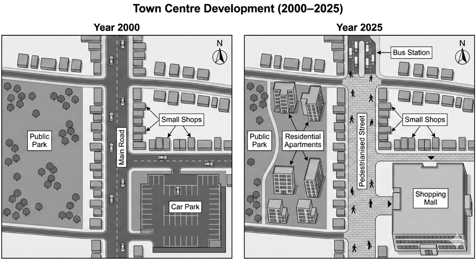
The maps below show the changes that took place in a town centre between 2000 and 2025.
Summarise the information by selecting and reporting the main features, and make comparisons where relevant.
Want to see your estimated band score?
Check your writing scorePart 1 · Band 9 Sample Answer
The maps compare the layout of a town centre in 2000 with its appearance following redevelopment by 2025.
Overall, the centre became far more pedestrian-oriented and gained substantial residential and commercial facilities. The southern part of the main road was closed to traffic, a bus station was established at its northern end, and a shopping mall replaced the car park. Part of the public park also made way for apartments, although a smaller green area and many existing shops remained.
In 2000, the main road ran north–south, crossing another road near the top of the map and meeting an eastbound street farther south. Small shops lined the main road and the streets to its east. A large car park occupied the south-eastern corner, while an extensive tree-filled public park covered most land to the west.
By 2025, the main road south of the northern junction and the former eastbound street had been converted into a broad pedestrianised zone. A bus station had been constructed immediately north of the junction. The shops around the eastern block and along the western edge of the walkway were largely retained.
The shopping mall occupied the former car-park site in the south-east. Opposite it, several apartment blocks were built across the central and eastern parts of the old park. Consequently, the park was reduced to a narrower area along the western side, still extending from the northern road towards the southern boundary.
Part 1 · Band 8 Sample Answer
The two maps illustrate how a town centre changed over the 25 years from 2000 to 2025.
Overall, the area was transformed from a car-focused centre into one with extensive pedestrian space and public transport facilities. A shopping mall replaced the car park, while the main road became a pedestrianised street. Apartments were also constructed on part of the public park, although a smaller park and most rows of shops were preserved.
In 2000, a main road passed vertically through the centre and crossed an east–west road in the north. Farther south, another road extended towards a large car park in the south-east. Small shops stood along the main road and around the block east of it. A sizeable tree-filled public park lay to the west.
By 2025, the main road south of the northern junction had been closed to vehicles and paved for pedestrians. The road leading east was also incorporated into this zone, beside a new shopping mall on the former car-park site. A bus station was added just north of the junction, and most surrounding shops stayed in place.
West of the centre, several apartment buildings were developed in the middle and eastern portion of the former park. As a result, the park became much smaller and was limited mainly to a strip along the western side, where numerous trees remained.
Part 1 · Band 7 Sample Answer
The maps show the changes made to a town centre between 2000 and 2025.
Overall, the centre became more suitable for pedestrians and gained new shopping, housing and public transport facilities. A shopping mall replaced the car park, and much of the main road became a pedestrian street. The park was reduced to provide land for apartments, while most small shops remained.
In 2000, the main road ran north–south through the centre. It crossed a road near the northern end, while another road led east towards a large car park in the south-east. Small shops stood beside these roads, and a large public park filled most of the western half.
In 2025, the section of the main road below the northern junction no longer carried vehicles. It became a wide pedestrian street, and the former road towards the car park was also paved for people on foot. A bus station was built north of the junction. The rows of shops beside the central area were largely unchanged.
The former car park was occupied by a large shopping mall. Across the pedestrian street, several apartment blocks had been constructed on the eastern and central parts of the old park. This left a smaller area of parkland along the western side, where groups of trees were retained.